Chopta
Chopta
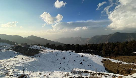
Chopta is a serene hill station and a hidden jewel nestled in the Garhwal Himalayas of Uttarakhand. Often referred to as the “Mini Switzerland of India,” Chopta is surrounded by lush meadows, dense forests of pine, deodar, and rhododendron, and offers breathtaking views of majestic Himalayan peaks like Nanda Devi, Trishul, and Chaukhamba.
At an altitude of around 2,680 meters, Chopta is the base for treks to Tungnath, the highest Shiva temple in the world, and further up to Chandrashila Peak, known for its 360-degree panoramic views. The region is a haven for trekkers, nature lovers, and bird watchers, home to rare species like the Himalayan Monal.
Unlike many commercial hill stations, Chopta remains untouched by heavy tourism, making it perfect for peaceful camping, sunrise views, and spiritual rejuvenation. Whether you’re looking for adventure, tranquility, or a spiritual escape, Chopta welcomes you with open skies and pristine landscapes.
How to Reach Chopta
Chopta, a tranquil hill station in the Rudraprayag district of Uttarakhand, is well connected by road and accessible via nearby railheads and airports. Here’s how you can reach Chopta from different parts of India:
🛣️ By Road:
Chopta is well-connected to major cities in Uttarakhand by motorable roads.
From Delhi:
Distance: ~450 km | Time: 12–14 hours
Route: Delhi → Haridwar → Rishikesh → Devprayag → Srinagar → Rudraprayag → Ukhimath → ChoptaFrom Rishikesh/Haridwar:
Distance: ~200–225 km | Time: 7–8 hours
You can hire a taxi or take a bus to Rudraprayag, then to Ukhimath, and finally to Chopta.Local Transport:
Shared jeeps and local buses are available from Rudraprayag, Agastyamuni, or Ukhimath to reach Chopta.
🚆 By Train:
Nearest Railway Stations:
Rishikesh (approx. 200 km)
Haridwar (approx. 225 km)
From these stations, you need to travel by road via Rudraprayag and Ukhimath to reach Chopta.
✈️ By Air:
Nearest Airport:
Jolly Grant Airport, Dehradun (approx. 220 km)
From the airport, hire a cab or take a bus to reach Chopta via Rishikesh → Rudraprayag → Ukhimath.
🏕️ Local Travel Note:
Roads are motorable up to Chopta, but in winter months (Dec–Feb), snowfall may block roads; in such cases, vehicles go only till Baniya Kund or Dugalbitta, and the rest of the distance is trekked.
✅ Travel Tip:
Best time to visit: March to June and September to November
Avoid monsoons (July–August) due to slippery roads and landslides
Other Tours
Other Trek
Itinerary
Morning:
Arrive at Chopta via road from Rishikesh/Haridwar/Dehradun
Check into a camp, homestay, or eco-lodge
Freshen up and enjoy a hot breakfast with stunning Himalayan views
Midday:
Explore the lush green meadows of Chopta
Visit nearby spots like Dugalbitta, Baniyakund, or Makku Bend
Optional: Birdwatching or short forest trails
Evening:
Enjoy a peaceful sunset view over Chaukhamba and Trishul peaks
Campfire, music, and dinner under the stars
Overnight stay in Chopta
Early Morning:
Start your trek around 4:30–5:00 AM to catch sunrise from Chandrashila
Trek Route: Chopta → Tungnath (3.5 km) → Chandrashila (1.5 km extra)
Visit Tungnath Temple, the highest Shiva temple in the world
At Chandrashila Peak:
Reach the top (~4,000 m) for a breathtaking 360° view of Himalayan ranges: Nanda Devi, Trishul, Kedarnath, Chaukhamba, and more
Meditate, click photos, and absorb the divine energy
Midday:
Descend back to Chopta (2–3 hours)
Rest and have lunch
Afternoon:
Check out and depart for your next destination (Rishikesh, Ukhimath, or Deoria Tal)
🏞️ Day 3 (Optional): Visit Deoria Tal (~20 km from Chopta), a stunning lake with mountain reflections
🛕 Combine with Kartik Swami Temple or Kalimath Shaktipeeth nearby
Carry warm clothes even in summer (Chopta is chilly year-round)
Wear proper trekking shoes, especially in winter or post-monsoon
Local guides are available for the trek (optional but helpful)
Carry water, snacks, sunglasses, and a power bank